Rally-style navigation · Mountain bike & trail
Ride the route,
not the map.
RoadbookX turns a trail into an ordered set of rally notes — tulip diagrams, distances, CAP headings, hazards — so your eyes stay on the terrain instead of a moving blue dot.
Current release: v1.6 for iOS · No account, no server · All data stays on your device
“Roadbook first. The map is a last resort.”
A roadbook builds trail instinct. A moving map trains dependency. RoadbookX borrows the navigation method used in Dakar-style rally raid and puts it on the bars of a bike.
Why a roadbook
A map shows you where the trail goes. A roadbook tells you what is actually on it.
Obstacles, turns and trail features are only a fraction of what a map carries — and most of the time they are not on it at all. A drop, a blind switchback, a washed-out corner, the fork that isn't signed: none of that survives the trip onto a base map. A roadbook records the trail turn by turn and element by element, in the order you meet them, at the distance you meet them.
Turn by turn
One instruction at a time with its distance, interval and CAP heading. You know what the next junction is before you can see it, instead of interpreting a line on a screen at speed.
Element by element
Every waypoint can carry difficulty, surface, grade, hazard level, built features and road resources. The berm, the rock garden, the water crossing and the gate are all part of the note.
Written by riders
Roadbooks are surveyed on the ground by the people who ride and maintain the trail, so the detail reflects the trail as it is today — not as it was digitised.
Shared and improved
Hand a roadbook to another rider and they can ride it, correct a note, add a hazard they found, and send it back. The trail knowledge compounds instead of staying in one person's head.
The workflow
Survey a trail once, and it becomes a roadbook you can ride, edit, reverse, and hand to another rider.
Record
Ride with GPS tracking and drop waypoints at turns, hazards and features. Position, odometer, heading and altitude are captured the instant you tap.
Edit
Clean the survey in the Roadbook Editor: instructions, distances, headings, difficulty, surface, notes. Reorder, insert, recalculate, bulk-edit.
Navigate
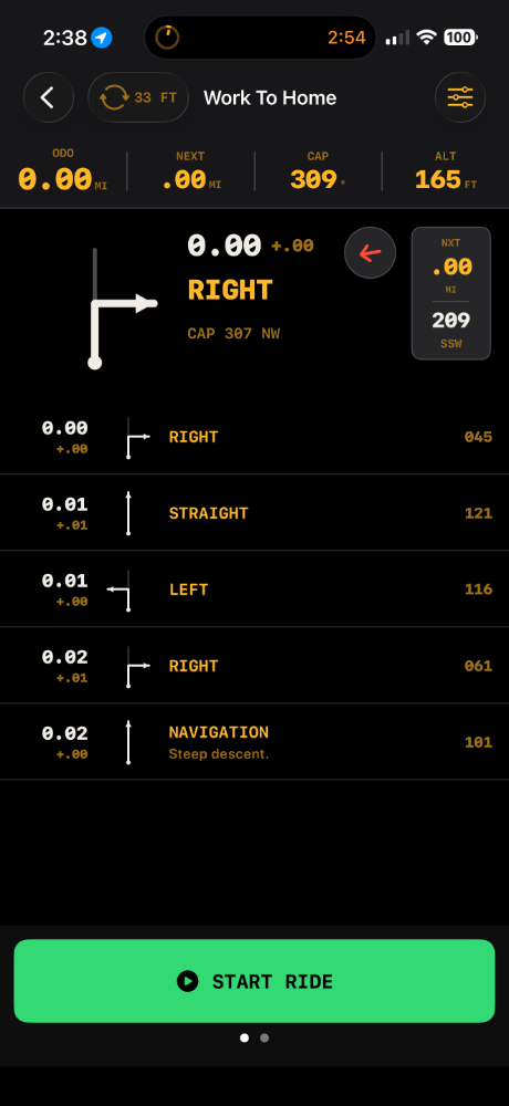
Rally Nav shows one instruction at a time on a full instrument panel, advancing automatically as you reach each waypoint.
Share
Export as .mtbrally with audio and annotations intact, or as standard .gpx for Garmin, Gaia GPS and Trailforks.
What it does
Built for gloves-on, one-handed use on the trail.
Rally Nav
Vector tulip diagrams for 20+ junction types, an instruction label, difficulty, surface, grade, features and hazard level — plus a colour-coded compass arrow and the upcoming notes list.
Record Route
Two rows of quick-add buttons adapt to the activity, a full waypoint sheet covers every field, and section difficulty carries forward until you clear it. Autosaves continuously; recovers after a crash.
Roadbook Editor
Generate turns from a bare GPX track, recalculate distances and headings from the recording, and build the reversed return route — mirrored turns, flipped headings — in one tap.
Voice notes
Record a memo at the exact spot. On-device speech recognition transcribes it into an editable note, playable in the editor and spoken back during navigation.
Library
Rides and routes stored locally with search, sort, activity filters and duplicate. Import .mtbrally or .gpx from Files, AirDrop or any share sheet.
Grade & elevation
Grade is computed for every interval from the recorded track and classified from flat to hike-a-bike. The elevation profile tints orange at 7% and red at 15%.
Trail maintenance mode
A survey dashboard for trail crew: six-decimal GPS readout, quick-tap grids for trail work and wildlife or environmental alerts, and voice findings. Position-focused, no distance or timer.
Export & interchange
.mtbrally carries the whole package, audio included, and lands straight in another rider's library. GPX export writes rally instructions into each waypoint plus an mtb: extension namespace.
On the bars
Dark panels, large digits, glove-sized targets — modelled on rally instrument binnacles.
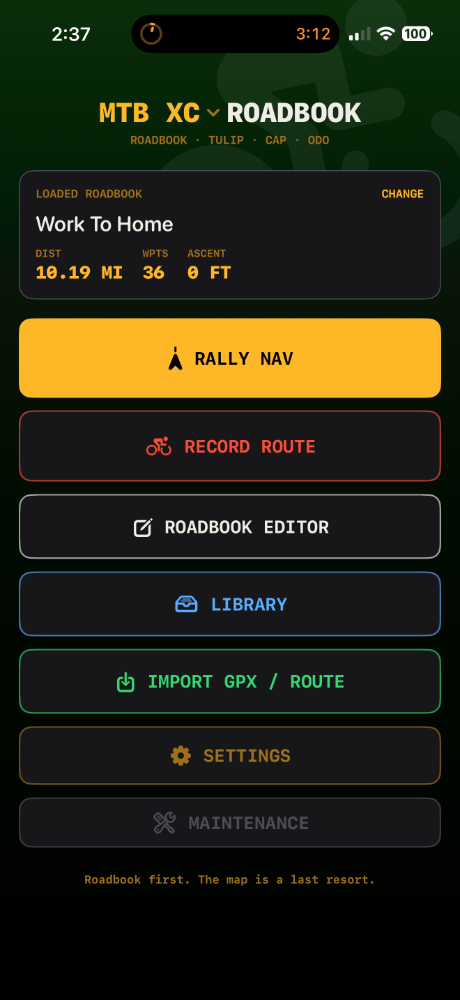
Loaded roadbook, activity mode, and every mode one tap away.
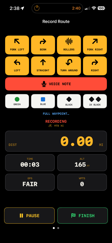
Quick-add turns and features, voice note, live survey stats.
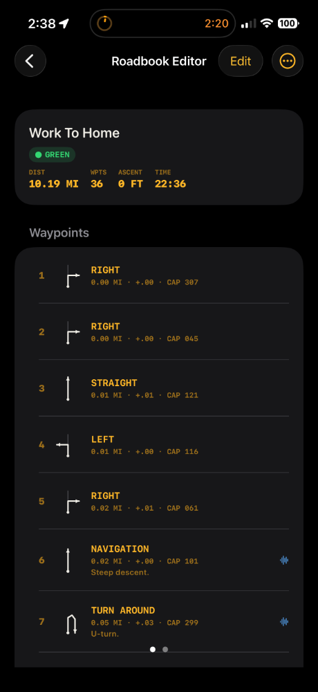
Every waypoint field editable, with recalculation from the track.
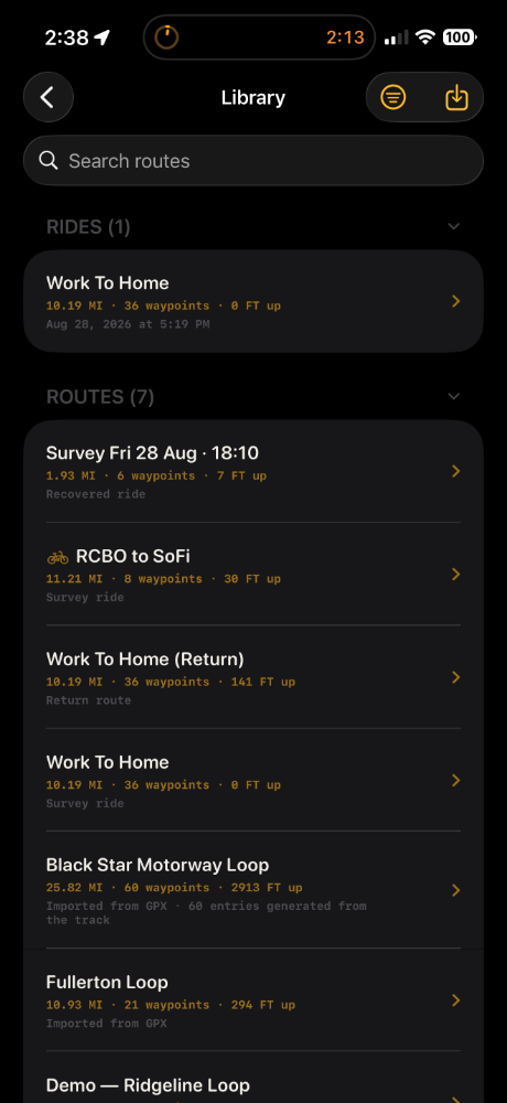
Rides and routes on the device, searchable and shareable.
Activity modes
The chosen mode changes the quick-add buttons, the hazard palette, the auto-advance distance and the dashboard.
| Mode | Primary hazard palette |
|---|---|
| MTB Cross Country | Roots, rocks, loose surface, mud, technical climbs, switchbacks, exposure |
| MTB Downhill | Drops, jumps, steep descent, rock gardens, slabs, exposure, speed |
| Gravel | Rough surface, loose gravel, vehicle crossings, cattle grids |
| Road | Traffic, enforcement, road works, crossings, steep sections |
| Hike | Steep climb, exposure, scramble, water crossing, cliff, loose rock |
| Horse | Gate, fence, mud, water crossing, steep climb, loud environment |
| 4×2 | Ruts, mud, water crossing, rock, soft sand, fallen tree |
| 4×4 | All of 4×2 plus steep descent, side slope, winch required |
| Kayak | Rapids, submerged rocks, strong current, portage, low-head dam |
| Trail Maintenance | Fallen tree, steep descent, steep climb, water crossing, rock garden |
Yours, on your device
No account. No server. No analytics.
Local storage
Routes, waypoints, voice recordings and preferences are stored in the app's own directory on the device.
You decide what leaves
Data only leaves the device when you share a route file yourself — AirDrop, Mail or Files.
Permissions in use only
Location is requested "when in use". The microphone and speech recognition run only while a voice memo is being recorded.
Open formats
.mtbrally is plain JSON, and GPX export stays compatible with the tools you already use.
Current release · iOS v1.6
Survey a trail.
Hand it to a rider.
RoadbookX v1.6 is the current release for iOS. Get in touch about trail crew use, route format feedback, or support.